
Apple ‘spy planes’ to film homes from the air
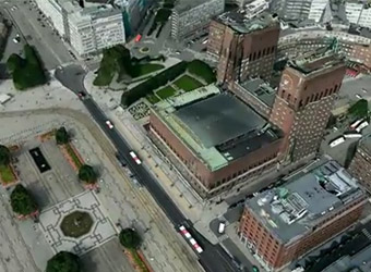
Apple has recruited a private fleet of aeroplanes equipped with military standard cameras to produce 3D maps so accurate they could film people in their homes through skylights, according to reports.
The US software giant is expected to announce this week a new “Maps” programme for iPhones and iPads allowing users to view images previously out of reach to anyone but the intelligence services.
Producing images of streets, homes and gardens so clear they will show objects just 4in across and display the sides of buildings as well as their roofs, the product is aimed as a direct challenge to Google Maps.
The technology is understood to have already been tested in 20 cities across the world including London following Apple’s acquisition of C3 Technologies, a Swedish 3D mapping business, last year.
Google, Apple’s arch rival, last week announced plans to generate 3D maps for entire metropolitan areas for use on its mobile devices, which will also involve the use of cameras mounted on aeroplanes.
In recent years the search engine has been heavily criticised for its use of Street View cars which photographed entire cities from street level and, the company later admitted, secretly harvested personal information from unsecured household wifi networks.